Taipei Historical Maps (com.adsc.taipeihistoricalmappp): With the swipe of a finger, discover Old Taipei! ... Read More > or Download Now >
Taipei Historical Maps for Android
Tech Specs
- • Latest Version: 2.0.1
- • Updated: September 27, 2020
- • Requires: Android 5 and up
- • Developer: 中央研究院數位文化中心 ASCDC
- • Content Rating: Everyone
User Reviews

- • Rating Average
- 4.44 out of 5
- • Rating Users
- 260
Download Count
- • Total Downloads
- 7
- • Current Version Downloads
- 2
- • File Name: com.adsc.taipeihistoricalmappp.apk
You can now download the latest version apk file or old version apk file and install it.
More About Taipei Historical Maps App
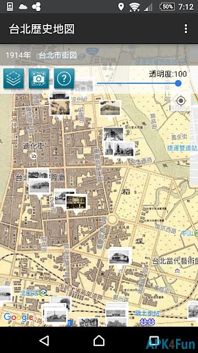
Taipei Historical Maps Description: Taipei Historical Maps combines maps and photographs recorded between 1895 and 1974, and integrates them into present-day Taipei using Google Maps and Street View. Equipped with geographical location referencing, the app allows users to transcend history to see how Taipei has changed over time with the help of maps and photographs.
The Center for Geographic Information Systems (GIS) of the Research Center for Humanities and Social Sciences (RCHSS), Academia Sinica, has provided ten different street maps of Taipei dating from various time periods. All of the maps depict a general view of the area inside the city wall, Mengjia (Bangka) (present-day Wanhua District), and Dadaocheng. Other contributions include 131 old photographs from the collections of the Institute of Taiwan History at Academia Sinica, the National Diet Library of Japan, and Sunnygate Phototimes.
Disclaimer:
1. The maps provided are for reference purposes only; geographical accuracy is not guaranteed. The GIS is not responsible for any liabilities incurred by the use of this app.
2. The Google Maps and Street View functions may require an internet connection.
What's New in Taipei Historical Maps 2.0.1 >
fix bug