onX Hunt (onxmaps.hunt): Go hunting & fishing with onX Hunt GPS. Outdoor landowner maps, property lines. ... Read More > or Download Now >
onX Hunt for Android
Tech Specs
- • Latest Version: 22.20.0
- • Updated: May 24, 2022
- • Requires: Android 6 and up
- • Developer: onXmaps
- • Content Rating: Everyone
User Reviews

- • Rating Average
- 4.63 out of 5
- • Rating Users
- 50553
Download Count
- • Total Downloads
- 129
- • Current Version Downloads
- 1
- • File Name: onxmaps.hunt.apk
You can now download the latest version apk file or old version apk file and install it.
More About onX Hunt App
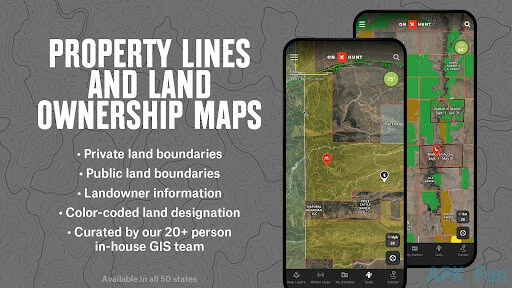
onX Hunt Description: Private and public land ownership data available in all 50 states
★★★ The onX Hunt App has been featured in Field & Stream, Outdoor Life (hiking, biking, etc.) and American Hunter as a must-have Hunting app for any Hunter or Outdoor Enthusiast ★★★
Know where you stand with the most trusted and accurate GPS sat/topo maps: Use onX Hunt as a fully functioning GPS Navigation on your phone. View private and public property land ownership and land owner names on the maps! Hunting and fishing units, mountain, roads and trails, US topographic maps and more! Turn your phone into the best hunting GPS with offline maps and location tracker!
▶ FREE HUNTING APP FEATURES:
• NO ADS
• Aerial view maps and 24K Topographical Maps with GPS Navigation
• Local weather conditions, forecast, wind speed, and wind direction sourced from the National Oceanic Atmospheric Administration (NOAA)
• Aerial/Topographic Hybrid overlay to see contours with satellite imagery
• Hunting Zones, Areas or Game Management Units (GMU) for general game species in all 50 states
• Free Hunting GPS app with compass, tracker and waypoints: mark waypoints with icons to navigate back to your vehicle, camp, or hunt stand
• Easily measure distances between tree stands and blinds
• Measure acreage with the Shape Tool to easily measure food plots
• Track the distance, coordinates, duration and speed of your hunt with our GPS Hunting Tracker
• Complimentary mapping layers such as topographical maps, hiking trails, running and bike path
• Web Map for e-scouting at home and syncing data to your mobile. Web Hunting Map: www.onxmaps.com/web
▶ OFFLINE GPS FUNCTIONALITY:
The onX Hunt App turns your phone into an outdoor handheld GPS Navigator by using the GPS built into your phone or tablet to display your location on the sat/topo map. Cellular coverage is NOT needed, as tile saving technology allows you to save basemaps and layers for offline navigation.
Extensive collection of Rec points, hiking and bike trails, backcountry roads, hot springs, Fire towers, and more.
▶ WEB MAP: Memberships also include access to our online Web Hunting Map (www.onxmaps.com/web) for computer use!
• Scout from the comfort of your home
• Sync markups and tracks between devices
• Print unlimited free maps
▶ FREE TRIAL:
While the onX Hunt App and many of it’s features are free, you will also start a free Premium State Membership trial when you install the App. This allows you to try a full featured Premium State Membership for 7 days.
▶ PREMIUM STATE MEMBERSHIP:
With a Premium State Membership you gain access to our proprietary hunting GPS maps developed by our GIS team. A Premium State Membership costs $29.99/year. Get the same great features of the free onX Hunt App but with the additional benefits of:
• Public land like Forest Service, Bureau of Land Management (BLM maps), Wildlife Management Areas, County and State land hunting/fishing maps, Timber Lands, QUADS and more!
• Landowner names with property line maps and boundaries finder in available counties (U.S. only)
• Search by landowner name or Hunting property landowner boundaries to scout and look for new areas to Hunt.
• Save private, or public hunting land maps for offline use
• GMU or Hunting Units for multiple species (e.g. Whitetail Deer, Mule Deer, Elk, Turkey Hunting and more)
• Possible Access Lands, Walk-In areas, Block Management Areas and private lands open to the public.
• The largest database of nationwide Roads and Trails ever built.
* Private landownership maps may not be available for all counties (U.S. only)
View the complimentary county layer on the Map or visit our website.
ELITE NATIONWIDE MEMBERSHIP
With an Elite Membership, you gain access to our proprietary maps for all 50 states. Easily scout and plan hunts in any state now for one membership price. Available for $99.99/year or $14.99/month.
▶ FEEDBACK:
Having a problem, or want to request new features please contact us at support@onxmaps.com